ForElite Training Institute
Home Training Calendar
Training Venues About Us Training Formats Blog
Home / Training Venues / Nakuru
Training Venue

Training in Nakuru

Green innovation training in Nakuru: Circular economy labs with flamingo views & geothermal agri-tech workshops in the Rift Valley.

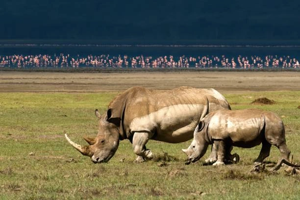
Training in Nakuru now unfolds as a living laboratory for green innovation, set against the dramatic backdrop of the Great Rift Valley. Experience circular economy workshops in eco-lodges overlooking Lake Nakuru's flamingo-fringed shores, agri-tech seminars at geothermal-powered greenhouses, and conservation entrepreneurship bootcamps inside the national park. Nakuru's new learning model blends field-based sustainability projects with cutting-edge theory—think renewable energy masterclasses followed by wildlife corridor mapping exercises, or regenerative business workshops paired with farm-to-table culinary experiences at flower farms. This is where environmental stewardship becomes a professional skill, taught in nature's own amphitheater.

9,413 Upcoming Sessions 1,236 Unique Courses 5★ Venue Rating

Upcoming Training in Nakuru

Search, scan, and open the course page for full details.

Training on GIS for Health and Disease Mapping
Geospatial Technologies and Remote Sensing Courses
Training on GIS for Health and Disease Mapping
Master GIS for health and disease mapping. Learn outbreak visualization, risk analysis, and planning for effective publi...
Start
17 Aug 2026
End
21 Aug 2026
5 Days GHDMC
Training on GIS Data Acquisition and Map Design with Google Earth
Geospatial Technologies and Remote Sensing Courses
Training on GIS Data Acquisition and Map Design with Google Earth
Master GIS data acquisition and map design using Google Earth Pro. Learn to collect, visualize, and present spatial data...
Start
17 Aug 2026
End
21 Aug 2026
5 Days TOGD584
Training on GIS and Remote Sensing in Land Cover and Change Analysis
Geospatial Technologies and Remote Sensing Courses
Training on GIS and Remote Sensing in Land Cover and Change Analysis
Master GIS and remote sensing for land cover mapping and land change analysis. Learn practical techniques for environmen...
Start
17 Aug 2026
End
21 Aug 2026
5 Days TOGA383
Training on GIS and Remote Sensing in Environmental Management, EIA and Audit
Geospatial Technologies and Remote Sensing Courses
Training on GIS and Remote Sensing in Environmental Management, EIA and Audit
Master GIS and remote sensing for environmental management and EIA. Learn spatial analysis, impact assessment, monitorin...
Start
17 Aug 2026
End
21 Aug 2026
5 Days TOGA601
Training on GIS and Remote Sensing for Climate Change Impact Analysis and Adaptation
Climate Adaptation and Resilience Planning Short Courses
Training on GIS and Remote Sensing for Climate Change Impact Analysis and Adaptation
Build practical skills in using spatial and satellite data to support climate resilience and policy development.
Start
17 Aug 2026
End
21 Aug 2026
5 Days TOGA131
Training on GIS and Remote Sensing in Agriculture, Food Security, and Climate Change
Geospatial Technologies and Remote Sensing Courses
Training on GIS and Remote Sensing in Agriculture, Food Security, and Climate Change
Master GIS and remote sensing for agriculture and food security. Learn crop monitoring, climate analysis, and spatial to...
Start
17 Aug 2026
End
21 Aug 2026
5 Days TOGA271
Training on GIS & Remote Sensing in Agriculture, Food Security and Climate Change
Geospatial Technologies and Remote Sensing Courses
Training on GIS & Remote Sensing in Agriculture, Food Security and Climate Change
Master GIS & Remote Sensing applications in agriculture, food security, and climate change adaptation.
Start
17 Aug 2026
End
21 Aug 2026
5 Days TOG&504
Training on GIS and Agriculture Applications
Geospatial Technologies and Remote Sensing Courses
Training on GIS and Agriculture Applications
Learn GIS for agriculture. Master soil mapping, crop monitoring, irrigation planning, and spatial analysis for precision...
Start
17 Aug 2026
End
21 Aug 2026
5 Days TOGA578
Training on Geospatial Data Analysis with R
Geospatial Technologies and Remote Sensing Courses
Training on Geospatial Data Analysis with R
Master geospatial data analysis with R. Learn spatial data manipulation, visualization, and mapping to drive informed de...
Start
17 Aug 2026
End
21 Aug 2026
5 Days GDARC
Training on Geospatial Data Analysis with Python
Geospatial Technologies and Remote Sensing Courses
Training on Geospatial Data Analysis with Python
Master geospatial data analysis with Python. Learn to analyze spatial data, create interactive maps, and extract insight...
Start
17 Aug 2026
End
21 Aug 2026
5 Days GDAPC
ForElite Training Institute

SECURE YOUR COMPETITIVE ADVANTAGE TODAY.

Subscribe to the Premier Intel newsletter for weekly market insights and training updates.

New message